South Esk Catchment Area Plan launched
A plan to protect and enhance the River South Esk and its catchment area was officially launched at Tannadice Primary School on Monday 14 December.
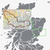
The River South Esk catchment is the area of land drained by the river and its burns, including its lochs, groundwaters, wetlands, and the unique estuary of Montrose Basin.
The catchment supports a wide range of economic activity in industries such as farming, forestry, fisheries, tourism and recreation and supports a rich variety of wildlife.
The completed plan follows an extensive consultation process, which involved two public meetings, and discussion with land owners, land managers and organisations with an interest in the South Esk catchment, including recreational clubs, angling groups and schools.
The aim of the plan is to bring together all those who use the catchment to decide the main environmental, social and economic issues and agree action that will guide the way activities are managed in the future in a joined up and long term way.
Visiting Tannadice Primary School for a tree planting ceremony to mark the launch of the plan, Angus Council's Infrastructure Services convener David May said: "The River South Esk catchment is of immense importance to Angus. With industries such as farming, forestry, fisheries and tourism all taking place within the boundaries of the catchment, this area provides many people in the Angus area with employment. It also provides opportunities for leisure pursuits including walking, canoeing and cycling and supports a great variety of wildlife and plants.
"The launch of this plan will now allow the council and its partners to manage this invaluable resource in a sustainable way with agreed actions which will guide the future management of activities within the catchment area."
Geographic Location